
VI. The Sun's Motion
- Page ID
- 5915
| Contents |
Optical Air Mass and Daily Motion
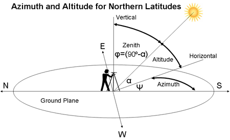
Optical air mass, discussed in the previous section, is a measurement of the angle at which the sun's incident light hits the surface of the earth. This measurement, of course, is very local; in fact, our noon is not directly overhead, but rather a local solar noon. This just means that as the sun passes overhead, it really maintains only a maximum angle at its height, but is not perfectly overhead except at the equator on the Spring and Fall equinoxes1. This would mean an elevation angle, or the anglular height of the sun measured from the horizontal (above the horizon), of 90°. The elevation angle is also often referred to as an altitude angle.
Source: "Solar Power." <http://www.mpoweruk.com/solar_power.htm>
The zenith angle is another angular measurement, however this is measured from the vertical, or from a line going through the center of the earth and through the coordinate one is standing. In other words, the zenith is at a maxmium 90° angle when the elevation is at a 0° angle. The following equation holds:
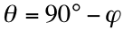
where θ is the elevation angle and ϕ is the zenith angle. One is just 90 minus the other. If we incorporate the declination of the earth δ into this relation, we can see that we would have to add the declination angle to the zenith angle, because the declination is a measure of the tilt of the axis form vertical (relative to the sun’s plane). Thus, we have the following equation for the Northern Hemisphere (where the angles are positive):

The signs of ϕ and δ would merely be reversed for the Southern Hemisphere, where the angles would be the opposite at a given time of year. These angles change daily, but there are many seasonal factors that come into play in determining how these daily motions change throughout the year.
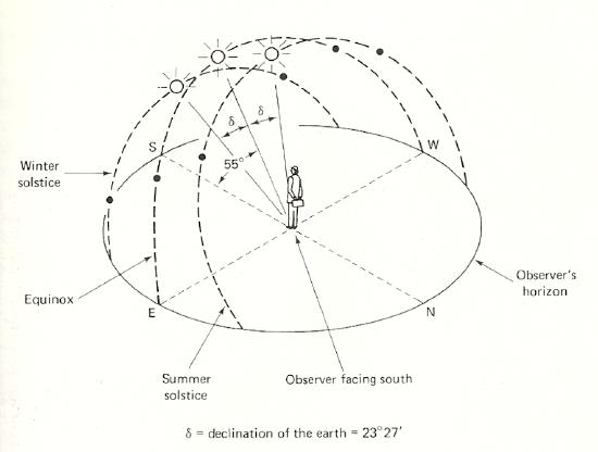
Declination of the Earth
It is worth noting that besides the daily change in sunlight, there is also the motion of the apparent “noon” throughout the year, as the earth’s tilted axis causes the sun to increase or decrease its angle relative to us by the declination angle of the earth, which is about 23.45°. This means that at any given latitude (location on the earth), throughout the year the sun will appear to take a path that raises and lowers relative to an observer. However, this changes from region to region; furthermore, seasons in different regions may have completely different meanings when it comes to solar radiation. The two types of apparent motion of the sun (daily and annual) should not be confused.
The earth, having a tilted axis of rotation relative to its orbit of the sun, means the angle at which the sun hits a given coordinate on the earth varies seasonally throughout the year. Only during the Spring and Fall equinoxes (the period during which the earth's tilt relative to the sun is negligible, or when the center of the sun is in the earth's plane) is the earth's declination angle 0°. However, during the Winter and summer solstices (when the deviation from the tilt is greatest, hence the extreme weather), the maximum declination angle is reached on either the positive or negative side.
Solar Insolation Data
The latitude and longitude (the coordinates) of a region determines what time of the year allows for maximum solar irradiance, along with other factors such as climate, altitude, and cloud cover. As will be discussed in the next section, the cloud cover of a region leads to a much higher percentage of AM0 radiation that is diffuse; various other factors besides purely location come into play. Solar insolation data has been compiled for various regions of the world, taking into account both direct and diffuse components throughout the year. The main point is that terrestrial sunlight varies by region and time in availability, intensity, and spectral composition, therefore having full knowledge of solar efficiency in each region requires a database of annual solar coverage2.