
21.2: Investigation
- Page ID
- 30298

Activity A – Temperature and precipitation
Begin by launching the Tribal Climate Tool in your web browser <https://climatetoolbox.org/tool/future-tribal-climate>. You will first be asked to select a tribe. Select “Quinault Indian Nation” from the drop-down menu that appears and click on “Go to Tool” button in dialogue box. Figure 21.2.1 shows the screen you should see after you do all this.
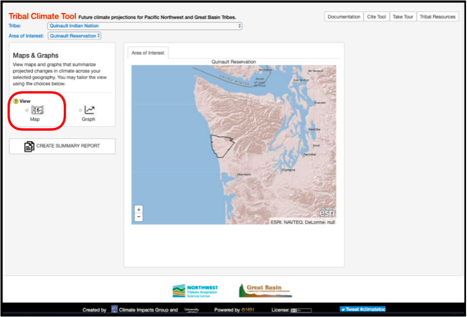
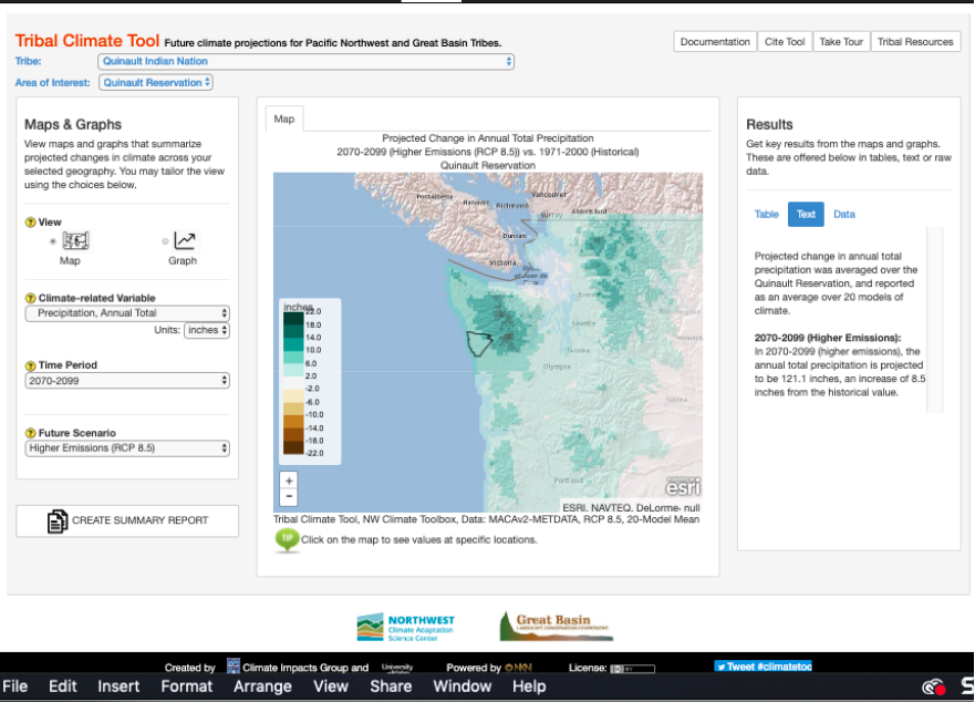
Begin your investigation of this community by selecting the map option in the view menu in the left panel of the frame. This is circled in red in Figure 21.2.1. What you will see when you do so should look like Figure 21.2.2. By default, you will see a map of projected change in annual total precipitation for 2070-2099 vs. 1971-2000 for Western Washington. The projected change is based on a high emission (RCP 8.5\(^{4}\)) scenario. Using the “+” / “- “ below the color scale, zoom in on the reservation. This area is on the central Washington coast and is outlined in black.
Questions - Current and projected temperature and precipitation
- How much of a change in annual total precipitation is the forecast for the late 21st century? Where in the reservation is the change the largest? To answer this question, click anywhere within the boundaries of the Quinault?
- How does Apr-Sept precipitation in 2070-2099 compare to 1971-2000 for the high emission scenario? How does Oct-Mar 2070-2099 compare to the same season in 1971-2000? What is the magnitude of these changes? To address these questions, select “Precipitation, Mar-Oct Total” and “Precipitation, Apr-Sept Total” from the pull-down Climate-related variables menu.
- Based on the high emission scenario how much does the average annual daily temperature of the Quinault change between the late 20th and late 21st centuries?
- What is the change in the number of high heat days (T > 30°C) by the end of this century?
- What is the change in the number of freeze free days?
- What general statement can you make about the relationship between changes in temperature and precipitation? Is this relationship consistent when you look at temperature and precipitation changes under the low emission scenario?
- Given the basic characteristics of the Quinault lands found in the background of this activity set, what would be some key impacts of the temperature and precipitation changes on the people living on this land?
Activity B – Streams and snow pack
Two variables closely tied to temperature and precipitation changes is peak stream temperature and seasonal flow. To investigate these variables, switch the “Future Scenario” back to higher emissions and then select “Stream Temperature, Aug Average” from the “Climate-related variable” menu.
Questions - Current and projected stream flow
- How much does peak average stream temperature change by the end of the 21st century? Note – Peak temperatures customarily occur in August.
- How many stream gauges appear in the Quinault reservation? What streams are they on? To find this out select “Streamflow, Jul-Sept Minimum” from the “Climate-related variable” menu and then click on any of the dots that appear within the reservation boundaries.
- For the Jul-Sept period, what is the percent decrease or increase in the flow at each station?
- For the Jan-Dec period, what is the percent decrease or increase in the flows at each station?
- What general statement can you make about late 21st century changes in stream temperature and seasonal flow under the high emission scenario? Does this relationship stay consistent when you look at stream temperature and flow changes in a low emission scenario?
- What would be the impact of the forecasted stream temperature and flow changes on the fisheries of the Quinault? The tribe runs ocean going fisheries and a seafood canning operation, as well as a fish hatchery.
A climate variable included in the Tribal Climate Toolkit (TCT) is snow water equivalent (SWE). SWE is a measure of the amount of water stored as snow or glacier ice at key times of the year. In the case of TCT this is either April 1 or May 1. The importance of this to the Quinault area is that many of the streams passing through the reservation have their headwaters in the neighboring Olympic Mountains. These mountains receive considerable snowfall during the winter which remains in storage until late spring and summer when it melts and feeds surrounding streams. To investigate changes in this storage, switch the future scenario back to high emission.
Questions - Current and projected snow pack
- How does the late 21st century change in SWE within the reservation compare to that of the mountains the east? To investigate this question, select “Snow Water Equivalent, May 1st Average” from the climaterelated variable menu.
- How would you explain the changes you saw in the previous question?
- How did the change in SWE and April-September precipitation explain the change in July-September stream flow?
- Under which emissions scenario does highland snow and ice provide a better buffer for reduced summer stream flow? In other words, in which scenario is there more late season water storage?
Activity C – Vegetation and Fire
Two interrelated variables, that are highly dependent on changes in temperature and precipitation, are the vegetation composition and frequency of high fire danger days. The former is the mix of major vegetation making up the land. In TCT the mix forecasted for the late 21st century is dependent on the emission scenario and whether or not forest fires are actively suppressed (the traditional approach to US forest management) or left to burn in controlled circumstances. In TCT fire danger is represented as projected change in the number of days per year in which the danger was rated as either “very high” or “extreme”. These determinations are based on the amount of moisture in dead vegetation that is between 2 and 8 cm in diameter.
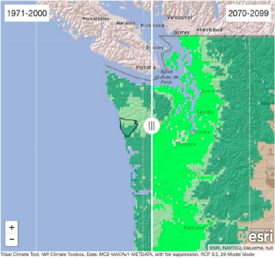
Begin investigating changes in vegetation by selecting “Vegetation Composition (with Fire Suppression)” from the climate related variable menu. When you do this, you should get a map that looks like Figure 21.2.3.
Questions - Current andn projected vegetation
- What is the historical composition of the vegetation in the reservation?
- What is the late 21\(^{st}\) century composition of the vegetation given active fire suppression?
- Assuming a high emissions scenario, does fire suppression have any impact on the late 21\(^{st}\) century composition?
- How does selecting a low emissions scenario impact the late 21\(^{st}\) century composition of the reservation forest?
- Which scenario would have the least impact on current logging operations? What is the rationale for your hypothesis? What additional information do you need to test your hypothesis?
- Many native peoples still practice traditional foraging activities such as gathering berries, herbs, etc. What relevance does what you concluded in questions 1-4 have to these activities?
To examine changes in fire danger, select “Very High Fire Danger Days Annual Total” from the climate-related variable menu.
Questions - Fire hazards
- How does the projected change in the number of annual very high danger days under a high emissions scenario compare to the projected change under a low emissions scenario?
- What factors influence what you concluded in the preceding question?
- Given the problems associated with active fire suppression, increased use of controlled burning is being widely advocated by forestry experts. Given what you concluded in question 8, in which of the two emission scenarios would controlled burning need to be used more actively and why?
Activity D – Synthesis
To synthesize what you’ve found out in the past three activities, make a table listing the climate-related variables you’ve looked at, the expected changes under the low and high emission scenarios and the cultural and economic activities of the tribe that will be impacted by these changes. In the final column of the table list one or two strategies that could use to adapt to these changes.
Final note:
An additional climate-variable to investigate and include in your synthesis table is sea level. This variable is important to consider largely because the two major settlements in the reservation are located at the mouth of two rivers that run through it. While rising sea level can be a problem for low lying communities in and of itself, it is also a factor that can exacerbate flooding from increased stream runoff and storm surges (bulges of water that develop under cyclonic storms). Furthermore, rising sea level increases the community’s vulnerability from tsunamis, and since the Washington coast is an active earthquake zone, it is increasing a factor to be considered. Therefore, a final question to consider in your synthesis table, is, what the projected late 21\(^{st}\) century sea level rise is under both high and low emission scenarios.