
8.4: The Hydrologic Cycle
- Page ID
- 12278
The major water reservoirs on Earth are oceans, glaciers, groundwater, rivers, and lakes. Water spends different amounts of time in the various reservoirs. The main factors that control the amount of time water stays in a reservoir are the amount of water in the reservoir and how fast water moves in and out. The hydrologic cycle (water cycle) represents a continuous global cycling of water from one reservoir to another (Figure \(\PageIndex{1}\)).
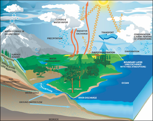
To gain a deeper appreciation of the water cycle, let us follow a water molecule through the water cycle. Starting in the ocean (an arbitrary starting point) the water molecule can become part of the water that is converted into vapor and enter the atmosphere. Heat energy from the sun, which drives the water cycle, heats water in the oceans and cause evaporation. Evaporation is the process by which water changes from a liquid to a gas or vapor. Evaporation is the primary pathway that water takes from the liquid state back into the water cycle as atmospheric water vapor. Nearly 90% of moisture in the atmosphere comes from evaporation, with the remaining 10% coming from transpiration. Transpiration is the process by which moisture is carried through plants from roots to small pores (stoma) on the underside of leaves, where it changes to vapor and is released to the atmosphere. Transpiration is essentially evaporation of water from plant leaves. Rising air currents take the vapor up into the atmosphere, along with water from evapotranspiration, which is a combination of water transpired from plants and that evaporated from the soil. The vapor rises into the air where cooler temperatures cause it to condense into clouds. Condensation is the process by which water vapor is converted from gaseous state back into liquid state. Clouds might eventually grow bigger and moist enough to release the water molecule in the form of precipitation. Precipitation is water falling from the clouds in the atmosphere in form of ice (snow, sleet, hail) or liquid (e.g. rain, drizzle). Precipitation that falls as snow can accumulate as ice caps and glaciers.
Did you know that the largest glacier on Earth is the Severny Island ice cap in the Russian Arctic?
Precipitation that falls as liquid usually ends up as surface flow and stream flow. Surface runoff is precipitation which travels over the soil surface to the nearest stream channel. Stream flow is the movement of water in a natural channel, such as a river. Most precipitation falls directly onto the ocean and returns the water molecule back to restart the journey. This is also true for surface runoff, most of the water eventually returns to the ocean via stream flow. This also returns the water molecule back the ocean to start the journey again.
A portion of the water that falls as precipitation can enter lakes where it can evaporate back into the atmosphere, condense, and fall back as precipitation again. Water in the lake can also be taken up by plants and transpired back into the atmosphere. Some of the water that falls as precipitation can infiltrate into the ground and become part of groundwater. Infiltration is the process by which water enters the subsurface by gravitation pull. Some of the water infiltrates into the ground and replenishes aquifers (saturated subsurface rock), which store huge amounts of freshwater for long periods of time. Some infiltration stays close to the land surface and can seep back into surface-water bodies (and the ocean) as groundwater discharge, and some groundwater finds openings in the land surface and emerges as freshwater springs. Plant roots absorb yet more groundwater to end up as evapotranspiration from the leaves. Over time, though, all this water keeps moving and most of it ends up in the ocean.
Components of the Hydrologic Cycle
Most precipitation falls in the form of rain but there are other forms such as snow, hail, and sleet. Once it runs sufficiently, surface water runoff is generated when the ground is saturated or impervious. Surface water is a major component of the hydrological cycle and one that we interact with very regularly. It includes lakes, wetlands, stormwater runoff (overland flow), ponds, potholes, rivers and streams.
Streams and Rivers
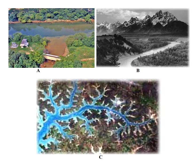
A river forms from water moving from a higher altitude to lower altitude, under the force of gravity. When rain falls on the land, it either evaporates, seeps into the ground or becomes runoff (water running on the surface). When water runs on the land surface it usually converges as it moves towards lower elevation. The converging runoff can concentrate into single channels of conveyance called creeks, stream, or rivers. Usually these start as small rill and rivulets that would join up downhill into larger streams and creeks which can also join up downstream to form even bigger rivers. The streams and rivers that join up to form a larger river are called tributaries, Figure \(\PageIndex{2}\). The land area drained by a river and all its tributaries is called a watershed or catchment or river basin.
The area adjacent to a river that floods frequently is a called a floodplain. Floodplains are areas that rivers use to temporarily store excess water during storm events and frequently contain very fertile soils. This has historically encouraged humans to move into floodplains and use them for agriculture, resulting in a reduction in the capacity of the floodplain to act as temporally storage for excess water during storm events, causing increased damaging flooding downstream. Properly functioning floodplains reduce the negative impacts of floods (by reducing severity of flood), and they assist in filtering stormwater and protecting the water quality of rivers. They also act as areas of recharge for groundwater.
.png?revision=1&size=bestfit&width=651&height=547)
The US has numerous rivers that run throughout the nation’s landscape. It is estimated that the US has over 200, 000 rivers with the Mississippi River being the largest by volume despite it only being the second longest. The Missouri River is the longest river in US. Most states have at least one important river. In Georgia, the main rivers are the Flint, Ochlockonee, Suwannee, Saint Marys, Satilla, Ogeechee, Altamaha, Oconee, Savannah, Chattahoochee, Tallapoosa, Coosa, Ocmulgee and the Tennessee rivers (Figure \(\PageIndex{3}\)).
.png?revision=1&size=bestfit&width=417&height=561)
These rivers are very important for supplying water to the cities and populations of the states. The rivers also contain important biological communities and provide opportunities for recreation such as swimming, fishing, and white water rafting. Rivers are so important and largely control settlement patterns all over the world. Major cities, communities, factories, industries, and power stations are located along rivers. It is, therefore, very important to protect the quality and integrity of rivers all over the world.
Unfortunately, most of the rivers in the world are too polluted to support certain human activities, especially swimming, fishing, and drinking. Close to half of the rivers in the US have been deemed too polluted to support swimming and fishing. A lot of the rivers have also been channelized, dredged, or impounded by dams which have ruined their ability to support a lot of human and biological activities. It is estimated that over 600, 000 river miles have been dammed in the US. Benefits of dams to humans include providing a source of water (reservoirs and farms ponds), recreation waters and reducing local flooding. On the other side, dams can also have negative impacts on people and the environment. They can lead to increased severe flooding downstream of the dam, especially during high rain events.
The impoundments can trap stream sediments resulting in reduced sediment supply downstream as well as increased deposition behind the dam. This shift in sediments flow can disrupt and damage aquatic habitats and can increase downstream stream erosion due to lack of sediment supply. The impoundments can also prevent certain aquatic organisms from migrating either upstream or downstream, therefore reducing their range and abilities to survive environmental changes as well cutting them off from spawning areas. Construction of dams can also result in displacement of the local people and loss of traditional lands and cultural history. Reservoirs and ponds usually form behind these impoundments.
Lakes, Reservoirs and ponds
If water flows to a place that is surrounded by higher land on all sides, a lake will form (Figure \(\PageIndex{4}\)). A lake, pond or reservoir is a body of standing water on the land surface. When people build dams to stop rivers from flowing, the lakes that form are called reservoirs. It is estimated that over 300 million water bodies in the world are lakes, reservoirs, and ponds. Most of the Earth’s lakes (about 60%) are found in Canada. Even though lakes and rivers contain less than 1% of the Earths water, the US gets over two thirds (70%) of its water (for drinking, industry, irrigation, and hydroelectric power generation) from lakes and reservoirs. Lakes are also the cornerstone of the US’s freshwater fishing industry and are the backbone of the nation’s state tourism industries and inland water recreational activities. (http://water.epa.gov/type/lakes/)
.png?revision=1&size=bestfit&width=728&height=219)
Wetland
A wetland is an area which is home to standing water for notable parts of the year, has saturated soils for a large part of the year and has plants that require large amounts of water to survive. Wetlands include swamps, marshes, and bogs. Wetlands are identified using three characteristics: soils (water-saturated soils are present), hydrology (shallow water table) and vegetation (wetland plants that are adapted to areas that are saturated with water for long periods of time). Wetlands are very important areas of biological diversity and productivity. These are also important areas where geochemical and biological cycles/ processes are consistently taking place. For instance, wetlands are considered as areas of significant carbon sequestration (storage), which impacts global climate change. They also act as filters for storm-water runoff before it enters rivers and lakes.
Oceans
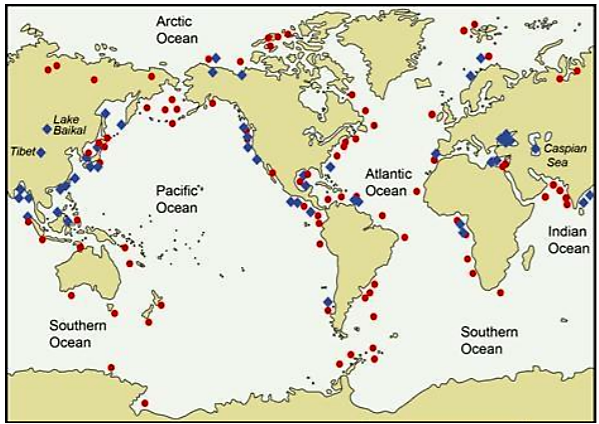
As you have probably already guessed, oceans are an important component of the hydrologic cycle because they store majority of all water on Earth (about 95%). Most of the major rivers drain into them. The five oceans covering the surface of the Earth are the Atlantic, Indian, Pacific, Arctic and the Southern Ocean (Figure \(\PageIndex{5}\)).
.png?revision=1&size=bestfit&width=489&height=346)
Approximately 90 % of the water that is evaporated into the hydrologic cycle comes from the ocean. Oceans are an important and large part of the hydrologic cycle, with lots biological diversity and many landforms. Did you know that the average depth of the oceans is about 3.6 km with a maximum depth that can exceed 10 kilometers in areas known as ocean trenches? The ocean is also home to many forms of life uniquely adapted to survive in this habitat. Unfortunately, humans have degraded the oceans and their life through pollution, overfishing, carbon dioxide acidification and resource exploitation. Figure 8.4.6 shows a couple of examples of human impacts on the ocean environment.
.png?revision=1&size=bestfit&width=724&height=235)
Also watch the video from the Habitable Planet: Oceans Video vwww.learner.org/courses/envs...nit=3&secNum=1
Groundwater
Storage and Flow
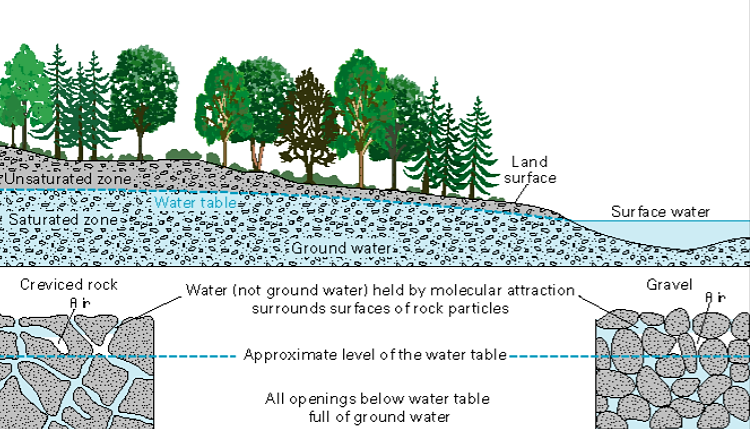
Almost 99% of the available fresh water is found below the surface as groundwater. Groundwater is not created by some mysterious processes below ground, but is part of the recycled water in the hydrologic cycle. When precipitation falls, some of the water runs off on the surface while some infiltrates into the ground. Groundwater is replenished when water moves from the surface, through unsaturated rocks or sediment (unsaturated), all the way down the saturated parts (saturated zone) in a process called infiltration and becomes groundwater (Figure \(\PageIndex{7}\)). The top of the saturated portion is called the water table, which is the boundary between saturated and unsaturated zone.
Groundwater is found in aquifers, which are bodies of rock or sediment that store (and yield) large amounts of usable water in their pores. Aquifer productivity is controlled by porosity and permeability. Porosity is the percentage of open space in a rock or sediment body. Permeability is the ability of subsurface material to transmit fluids. Groundwater is found in the saturated zone of a rock body where all pores are filled with water. An important concept is that surface water always moves from higher elevation to lower elevation while groundwater always moves from higher energy (hydraulic head) to lower energy.
.png?revision=1&size=bestfit&width=583&height=333)
Groundwater will continue to flow until it emerges as a spring, or discharges into surface water bodies on the land or in the ocean. To utilize groundwater, we drill holes (wells) into the ground and pump the water out.