
2: The Physical World
- Page ID
- 83382

\( \newcommand{\vecs}[1]{\overset { \scriptstyle \rightharpoonup} {\mathbf{#1}} } \)
\( \newcommand{\vecd}[1]{\overset{-\!-\!\rightharpoonup}{\vphantom{a}\smash {#1}}} \)
\( \newcommand{\dsum}{\displaystyle\sum\limits} \)
\( \newcommand{\dint}{\displaystyle\int\limits} \)
\( \newcommand{\dlim}{\displaystyle\lim\limits} \)
\( \newcommand{\id}{\mathrm{id}}\) \( \newcommand{\Span}{\mathrm{span}}\)
( \newcommand{\kernel}{\mathrm{null}\,}\) \( \newcommand{\range}{\mathrm{range}\,}\)
\( \newcommand{\RealPart}{\mathrm{Re}}\) \( \newcommand{\ImaginaryPart}{\mathrm{Im}}\)
\( \newcommand{\Argument}{\mathrm{Arg}}\) \( \newcommand{\norm}[1]{\| #1 \|}\)
\( \newcommand{\inner}[2]{\langle #1, #2 \rangle}\)
\( \newcommand{\Span}{\mathrm{span}}\)
\( \newcommand{\id}{\mathrm{id}}\)
\( \newcommand{\Span}{\mathrm{span}}\)
\( \newcommand{\kernel}{\mathrm{null}\,}\)
\( \newcommand{\range}{\mathrm{range}\,}\)
\( \newcommand{\RealPart}{\mathrm{Re}}\)
\( \newcommand{\ImaginaryPart}{\mathrm{Im}}\)
\( \newcommand{\Argument}{\mathrm{Arg}}\)
\( \newcommand{\norm}[1]{\| #1 \|}\)
\( \newcommand{\inner}[2]{\langle #1, #2 \rangle}\)
\( \newcommand{\Span}{\mathrm{span}}\) \( \newcommand{\AA}{\unicode[.8,0]{x212B}}\)
\( \newcommand{\vectorA}[1]{\vec{#1}} % arrow\)
\( \newcommand{\vectorAt}[1]{\vec{\text{#1}}} % arrow\)
\( \newcommand{\vectorB}[1]{\overset { \scriptstyle \rightharpoonup} {\mathbf{#1}} } \)
\( \newcommand{\vectorC}[1]{\textbf{#1}} \)
\( \newcommand{\vectorD}[1]{\overrightarrow{#1}} \)
\( \newcommand{\vectorDt}[1]{\overrightarrow{\text{#1}}} \)
\( \newcommand{\vectE}[1]{\overset{-\!-\!\rightharpoonup}{\vphantom{a}\smash{\mathbf {#1}}}} \)
\( \newcommand{\vecs}[1]{\overset { \scriptstyle \rightharpoonup} {\mathbf{#1}} } \)
\(\newcommand{\longvect}{\overrightarrow}\)
\( \newcommand{\vecd}[1]{\overset{-\!-\!\rightharpoonup}{\vphantom{a}\smash {#1}}} \)
\(\newcommand{\avec}{\mathbf a}\) \(\newcommand{\bvec}{\mathbf b}\) \(\newcommand{\cvec}{\mathbf c}\) \(\newcommand{\dvec}{\mathbf d}\) \(\newcommand{\dtil}{\widetilde{\mathbf d}}\) \(\newcommand{\evec}{\mathbf e}\) \(\newcommand{\fvec}{\mathbf f}\) \(\newcommand{\nvec}{\mathbf n}\) \(\newcommand{\pvec}{\mathbf p}\) \(\newcommand{\qvec}{\mathbf q}\) \(\newcommand{\svec}{\mathbf s}\) \(\newcommand{\tvec}{\mathbf t}\) \(\newcommand{\uvec}{\mathbf u}\) \(\newcommand{\vvec}{\mathbf v}\) \(\newcommand{\wvec}{\mathbf w}\) \(\newcommand{\xvec}{\mathbf x}\) \(\newcommand{\yvec}{\mathbf y}\) \(\newcommand{\zvec}{\mathbf z}\) \(\newcommand{\rvec}{\mathbf r}\) \(\newcommand{\mvec}{\mathbf m}\) \(\newcommand{\zerovec}{\mathbf 0}\) \(\newcommand{\onevec}{\mathbf 1}\) \(\newcommand{\real}{\mathbb R}\) \(\newcommand{\twovec}[2]{\left[\begin{array}{r}#1 \\ #2 \end{array}\right]}\) \(\newcommand{\ctwovec}[2]{\left[\begin{array}{c}#1 \\ #2 \end{array}\right]}\) \(\newcommand{\threevec}[3]{\left[\begin{array}{r}#1 \\ #2 \\ #3 \end{array}\right]}\) \(\newcommand{\cthreevec}[3]{\left[\begin{array}{c}#1 \\ #2 \\ #3 \end{array}\right]}\) \(\newcommand{\fourvec}[4]{\left[\begin{array}{r}#1 \\ #2 \\ #3 \\ #4 \end{array}\right]}\) \(\newcommand{\cfourvec}[4]{\left[\begin{array}{c}#1 \\ #2 \\ #3 \\ #4 \end{array}\right]}\) \(\newcommand{\fivevec}[5]{\left[\begin{array}{r}#1 \\ #2 \\ #3 \\ #4 \\ #5 \\ \end{array}\right]}\) \(\newcommand{\cfivevec}[5]{\left[\begin{array}{c}#1 \\ #2 \\ #3 \\ #4 \\ #5 \\ \end{array}\right]}\) \(\newcommand{\mattwo}[4]{\left[\begin{array}{rr}#1 \amp #2 \\ #3 \amp #4 \\ \end{array}\right]}\) \(\newcommand{\laspan}[1]{\text{Span}\{#1\}}\) \(\newcommand{\bcal}{\cal B}\) \(\newcommand{\ccal}{\cal C}\) \(\newcommand{\scal}{\cal S}\) \(\newcommand{\wcal}{\cal W}\) \(\newcommand{\ecal}{\cal E}\) \(\newcommand{\coords}[2]{\left\{#1\right\}_{#2}}\) \(\newcommand{\gray}[1]{\color{gray}{#1}}\) \(\newcommand{\lgray}[1]{\color{lightgray}{#1}}\) \(\newcommand{\rank}{\operatorname{rank}}\) \(\newcommand{\row}{\text{Row}}\) \(\newcommand{\col}{\text{Col}}\) \(\renewcommand{\row}{\text{Row}}\) \(\newcommand{\nul}{\text{Nul}}\) \(\newcommand{\var}{\text{Var}}\) \(\newcommand{\corr}{\text{corr}}\) \(\newcommand{\len}[1]{\left|#1\right|}\) \(\newcommand{\bbar}{\overline{\bvec}}\) \(\newcommand{\bhat}{\widehat{\bvec}}\) \(\newcommand{\bperp}{\bvec^\perp}\) \(\newcommand{\xhat}{\widehat{\xvec}}\) \(\newcommand{\vhat}{\widehat{\vvec}}\) \(\newcommand{\uhat}{\widehat{\uvec}}\) \(\newcommand{\what}{\widehat{\wvec}}\) \(\newcommand{\Sighat}{\widehat{\Sigma}}\) \(\newcommand{\lt}{<}\) \(\newcommand{\gt}{>}\) \(\newcommand{\amp}{&}\) \(\definecolor{fillinmathshade}{gray}{0.9}\)After completing this chapter, you will be able to
- Explain the geological structure and dynamics of planet Earth.
- Describe the importance of glaciation and other geological forces in modifying the landscapes of Canada.
- Outline the four major elements of Earth’s water cycle.
- Describe the atmosphere and its circulation.
- Explain the elements of climate and weather.
Introduction
In this chapter we examine various aspects of the physical world, including the origin of planet Earth and the nature and dynamics of its physical attributes. Understanding these subjects is important in environmental science because they provide a context for interpreting many of the changes that are being caused by human activities.
Planet Earth
The universe is thought to have originated as many as 12-15 billion years ago during a ginormous cataclysm known as the “big bang.” Initially, virtually all of the mass of the nascent universe consisted of the two lightest elements, hydrogen and helium, which existed as an extremely diffuse gaseous mass. Eventually, under the pervasive influence of gravity, the hydrogen and helium were aggregated into immense masses that became increasingly compressed under enormously high pressure and temperature. When the pressure and temperature were sufficiently intense, nuclear fusion reactions began to occur within the masses, at which point they had become young stars. In addition to releasing immense quantities of energy, the fusion reactions caused the formation of heavier elements. Because of these processes, there are now 88 naturally occurring elements. Hydrogen and helium are still, however, the most abundant elements, comprising more than 99.9% of the mass of the universe.
The Sun is an ordinary star, one of billions of billions that exist in the universe. The Sun, its eight orbiting planets, plus miscellaneous comets, meteors, asteroids, and other materials (such as space dust) are collectively known as the solar system. This particular region of the universe is organized and held together by a balance of the attractive force of gravitation and counteracting influences associated with rotation and orbiting (these same forces, along with continuing expansion from the initial big bang, also organize the universe). The age of the solar system (and of Earth) is at least 4.6 billion years.
Earth is the third-closest planet to the Sun. Earth is a dense planet, as are other so-called terrestrial planets located relatively close to the Sun: Mercury, Venus, and Mars. The mass of these planets consists almost entirely of heavier elements such as iron, nickel, magnesium, aluminum, and silicon. These inner planets were formed by a selective condensing of heavier elements out of the primordial planetary nebula (the disk of gases and other matter that slowly rotated around the Sun during the early stages of formation of its solar system). This happened because the inner planets were subjected to relatively intense heating by solar radiation, which caused lighter gases such as hydrogen and helium to disperse further away, to the extent that they ended up mostly in the outer, cooler planets. Meanwhile the terrestrial planets retained heavier elements. Consequently, the more distant planets in the solar system, such as Jupiter and Saturn, are relatively large, gaseous, and diffuse in character. Most of their volume is composed of an extensive atmosphere of hydrogen and helium, although these planets may contain heavier elements in their core.
Earth is the only place in the universe that is definitely known to sustain life. It is quite possible, however, that other planets in the cosmos also sustain life. Although there is no direct evidence of this, many scientists consider it likely that life has evolved elsewhere. One estimate suggests that the universe contains 1022 (10,000 billion billion) stars, with perhaps 10% of them having planetary systems (1021systems). With such incredibly large numbers, it is highly probable that at least some of the billions of billions of other planetary systems support suitable conditions for a genesis of life, in addition to what occurred on Earth.
Earth is a spherical body with a diameter of about 12,740 km. It revolves around the Sun in an elliptical orbit, at an average distance of about 149 million km, completing an orbit in 365.26 days, or one year. Earth also rotates on its axis every 24 hours, or one day. Its single moon has a diameter of about 3,474 km and a mass about 2% that of Earth. The Moon revolves around Earth in an elliptical orbit at an average distance of about 385,000 km, completed every 27.3 days (the lunar month).
The sphere of Earth is composed of four layers—the core, mantle, lithosphere, and crust—arranged in concentric layers like an onion. The massive core has a diameter of about 3,500 km and is composed of hot, molten metals, particularly iron and nickel. The internal heat of Earth is thought to be generated by the slow, radioactive decay of unstable isotopes of certain elements, such as uranium.
The mantle is a less dense region that encloses the core. It is about 2,800 km thick and composed of minerals in a plastic, semi-liquid state known as magma. The mantle contains relatively light elements, notably silicon, oxygen, and magnesium, occurring as various mineral compounds. Magma from the upper mantle sometimes erupts to the surface at mountainous vents known as volcanoes and is usually spewed to the surface as lava, which cools to form basaltic rock.
The next layer, the lithosphere, is only about 80 km thick and is made of rigid, relatively light rocks, especially basaltic, granitic, and sedimentary ones. These rocks contain elements found in the mantle as well as enriched quantities of aluminum, carbon, calcium, potassium, sodium, sulphur, and other lighter elements.
The outermost layer is known as the crust. Oceanic crust is relatively thin, averaging 10–15 km, while continental crust is 20–60 km thick. Earth’s crust has an extremely complex mineralogical composition, in contrast to the mantle and especially the core, which are thought to be relatively uniform in structure and constitution. The most abundant elements in the crust are oxygen (45%), silicon (27%), aluminum (8.0%), iron (5.8%), calcium (5.1%), magnesium (2.8%), sodium (2.3%), potassium (1.7%), titanium (0.86%), vanadium (0.17%), hydrogen (0.14%), phosphorus (0.10%), and carbon (0.032%).
The rocks forming the crust can be grouped into three basic types: igneous, sedimentary, and metamorphic. Igneous rocks include basalt and granite, which are formed by the cooling of molten magma. The mineral forms depend on the rate of cooling plus other factors. Basalt is a heavy, dark, extremely fine-grained rock that sometimes forms vertical, columnar structures. Basaltic rocks are the major constituent of oceanic crust, originating in submarine places where magmic lava erupts to the sea-floor surface, such as deep-ocean spreading zones and abyssal volcanoes. Basalt can also be formed at terrestrial volcanoes – for instance, it is the basement rock of the Hawaiian archipelago and other volcanic islands. Granitic rocks dominate the continental crust, are typically relatively light in colour and density, and are coarser-grained, with readily distinguishable crystals. The complex crystalline structure includes the minerals quartz and feldspar, and mica and hornblende are often present.
Sedimentary rocks include limestone, dolomite, shale, sandstone, and conglomerates. These form from particles eroded from other rocks or from precipitated minerals such as calcite (CaCO3) that become lithified (turned into stone) under great pressure in deep oceanic deposits. Sedimentary rocks typically overlie basaltic or granitic rocks.
Metamorphic rocks are formed from igneous or sedimentary ones that were changed under the combined influences of massive geological heat and pressure. These conditions were encountered when the primary rocks were carried deep into the lithosphere by crustal movements, such as those associated with mountain building (described below). Gneiss, for example, is a metamorphic rock derived from granite, while marble is derived from limestone, and slate from shale. About 30% of Earth’s surface is covered by the solid substrates of continents and islands. The other 70% of Earth’s surface is liquid water, almost all of which is oceanic. In addition, Earth’s dense sphere is immersed in a gaseous envelope known as the atmosphere, which extends to a distance of about 1,000 km. However, about 99% of the mass of the atmosphere occurs within 30 km of the planet’s surface.
Geological Dynamics
Throughout its history, Earth has been subject to enormous geological forces that have greatly affected its mineralogical composition and surface features. The predominant influences are tectonic forces, which are associated with crustal movements and other processes that cause structural deformation of rocks and minerals. Geological forces also cause the continents and their underlying plates to slowly move about Earth’s surface, much like rafts of solid rock riding upon a sea of plastic magma. Mountain ranges are built where crustal plates collide and push up surface rocks.
Earthquakes and volcanoes are also tectonic phenomena, which influence Earth’s crust and surface with extremely powerful, sometimes disastrous events. Other massive geological forces include rare, cataclysmic strikes into our planet by meteorites and extensive glaciation associated with cooling of the climate. Slower but still pervasive geological forces are erosion (caused by water, wind, and gravity) and weathering (the fracturing of rocks and dissolution of minerals).
Over geological time, these various physical processes have profoundly influenced the character of Earth. Geological forces continue to have enormous influences on Earth and its ecosystems, over both short- and long-term time scales. Environmental changes associated with these geological dynamics provide a natural context for the substantial changes that humans are now causing through their economic activities.
Meteorites
Earth is frequently struck by fast-moving rocky or metallic objects from space known as meteorites. Although meteorites are relatively small objects (by planetary standards), they have immense momentum because of their speed, which typically ranges from 10-100 km/s. The smallest, most numerous meteorites reaching Earth typically burn up or explode in the atmosphere because of heat generated by friction, but larger ones may survive to impact the surface. It has been estimated that each day a meteorite weighing at least 100 g strikes the surface somewhere in Canada.
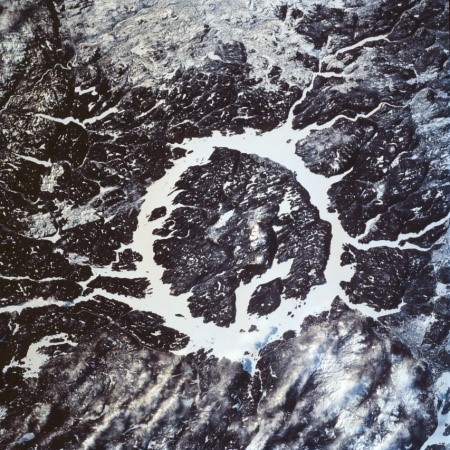
Very large meteorites are extremely rare, but if the impact the surface enormous damage is caused. The impact site is typically obliterated and a large crater is formed because vast amounts of crustal materials are ejected into the atmosphere. Immense sea waves can also be caused by a meteorite impact. Several dozen large meteorite craters are known in Canada. The largest is an ovoid depression with a diameter of 140 km near Sudbury, Ontario, caused by a meteorite strike occurring about 1,850 million years ago (Mya), and a doughnut-shaped lake with a diameter of 70 km at Manicouagan, Quebec, from an impact about 215 Mya ago. These extraordinary events must have caused tremendous damage to the species and ecosystems of the time.
Earth’s evolutionary history has been punctuated by a number of catastrophic events of mass extinction, during which most of the existing biota disappeared in a short period of time, to be later replaced by new species (see Chapter 6). Paleontologists recognize these cataclysms by the occurrence of rapid changes in the fossil record, which point to a transition between stages in the geological time scale (Table 3.1). According to surviving evidence, the most intense mass extinction event occurred 245 million years ago at the end of the Permian period, when an astonishing 96% of species may have become extinct. Another mass extinction occurred 65 million years ago at the end of the Cretaceous period, when perhaps 76% of species became extinct, including the last of the dinosaurs. According to one theory, the end-of-Cretaceous extinctions were caused when a 10–15 km wide meteorite impacted the Earth. This resulted in that huge amounts of fine dust being spewed into the upper atmosphere, which caused a severe cooling of the climate that large animals and many ecosystems could not tolerate. Some geologists believe that the impact site was near the Yucatan coast of Mexico, where a buried, 170-km-wide ring structure exists, dated to about 65 million years old. Although controversial, the theory of rare, meteorite-caused catastrophes has also been used to explain other mass extinctions in the geological record.
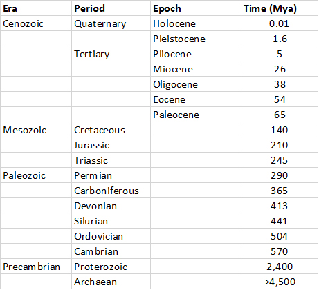
Plate Tectonics
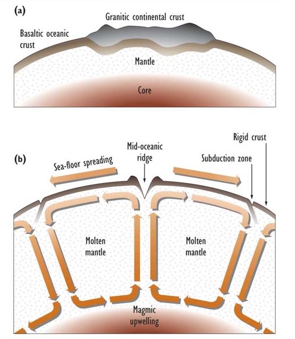
The theory of plate tectonics concerns the dynamics of surface crustal materials. In simple terms, this theory suggests that the crust and mantle behave as an enormous convecting system that, at the surface, is characterized by extremely slow movements of huge plates of rigid crustal material. The plates move from zones where they are created by an upwelling of magma from the upper mantle, toward other zones where they are destroyed by downward movement into the upper the mantle. In the creation zones, the plastic magma rises to the surface, solidifies, and then extends laterally in a process known as sea-floor spreading. In the down-welling zones, there is a subduction of sea-floor crust back down into the mantle, where it is re-melted and convected laterally. The magma may eventually reach another upwelling region and again be carried to the crust. The slowly moving, rigid plates of surface crust have a basement of basaltic rock, with lighter, granitic-based continents rafting on the surface of some of the oceanic plates (Figure 3.1).
For example, in the Atlantic Ocean, about halfway between the Americas and Europe and Africa, a deep-sea geological structure called the Mid-Atlantic Ridge runs in a roughly north to south direction. This abyssal ridge is a zone of sea-floor spreading, from which the two continental regions are diverging at a slow but steady rate of 2-4 cm/year. In essence, the Atlantic ocean is widening at this rate, which is equivalent to 2-4 meters per century.
In contrast, parts of the continental landmass in the western Americas are riding on regions of plates that are subducting beneath the oceanic Pacific Plate. However, along most of southwestern North America, the Pacific and North American Plates are moving in opposite but parallel directions. This is causing southern California and the Baja Peninsula to slowly move northward relative to the rest of the continent. This process is occurring along an extended but narrow zone of contact between the plates (a fault) known as the San Andreas Fault.
These tectonic forces result in frequent earthquakes and volcanic eruptions along the Pacific coasts of North and South America, the Aleutians, and eastern Asia. This geologically active region around the Pacific Ocean is referred to as the “ring of fire” because of its many volcanoes. In addition to these discrete but intense geological events, there is active building of the relatively young mountains in this region. The mountain building is caused by crustal materials being pushed upward in regions where continents and oceanic plates are colliding with each other. In a similar manner, the lofty Himalayas of southwestern Asia were and still are being created by immense uplifting forces that are generated as the northward-drifting Indian subcontinent pushes into the larger Asian landmass.
It is thought that the continents were a single contiguous mass during the Permian period, about 290 million years ago. This primeval super-continent, referred to as Pangaea, was surrounded by a single, global ocean. However, divergent forces of crustal plates moving in different directions then pulled Pangaea apart, initially into two masses known as Laurasia and Gondwanaland, and then into the existing continents of North and South America, Africa, Eurasia, Australia, and Antarctica.
An earthquake is a trembling or movement of the Earth caused by a sudden release of geological stresses at some point within the crust or upper mantle. Earthquakes are most often caused when crustal plates slip across or beneath each other at their faults, but they can also be caused by a volcanic explosion. Although their seismic energy can affect a large area, earthquakes have a spatial focus, known as the epicentre and defined as the surface position lying above the deep point of energy release. An intense earthquake can cause great damage to buildings, and the collapsing structures, fires, and other destruction can take a great toll on people. In 1556 an earthquake struck Shanxi Province in China and caused about 830,000 deaths, making it the most deadly earthquake in recorded history. The most famous catastrophic earthquake in North America was the San Francisco event in 1906, caused by slippage along the San Andreas Fault, which killed 503 people and resulted in tremendous physical damage. However, other earthquakes during the twentieth century resulted in much greater losses of human lives, including one in 1976 that killed 242,000 people in Tangshan, China; another in 1927 that killed 200,000 in Nan-Shan, China; and one in Tokyo–Yokohama, Japan, that killed 200,000 in 1926. Notable recent earthquakes include one in Kobe, Japan (1995) that killed 5,500 people, another in Kashmir (2005) that killed 79,000 people, one in Sichuan, China (2008) that killed 70,000 people, and one in the Tohuku region of Japan (2011) that generated a tsunami (seismic sea wave) that killed 16,000 people.
The events in San Francisco (1906) and Tokyo (1926) affected large cities. The powerful tremors caused great damage, partly because of weak architectural designs that were unable to withstand the strong forces. In both cases, however, about 90% of the actual destruction resulted from fires. Earthquakes can also cause soil to lose some of its mechanical stability, resulting in destructive landslides and subsidence (sinking) of land and buildings.
Undersea earthquakes can trigger a fast-moving, sea-surface phenomenon known as a tsunami or seismic sea wave. A tsunami is barely noticeable at sea, but it can become gigantic when the wave reaches shallow water and piles up to heights that can swamp coastal villages and towns. In 1929, an earthquake off eastern Canada generated a seismic sea wave that killed 29 people in Newfoundland and Cape Breton. In 1946, a large earthquake centred on Umiak Island in the Aleutian Islands caused a tsunami to strike Hawaii, 4,500 km away, with an 18 m crest. In 2004, a tsunami in the Indian Ocean killed more than 225,000 people (see Global Focus 3.1).
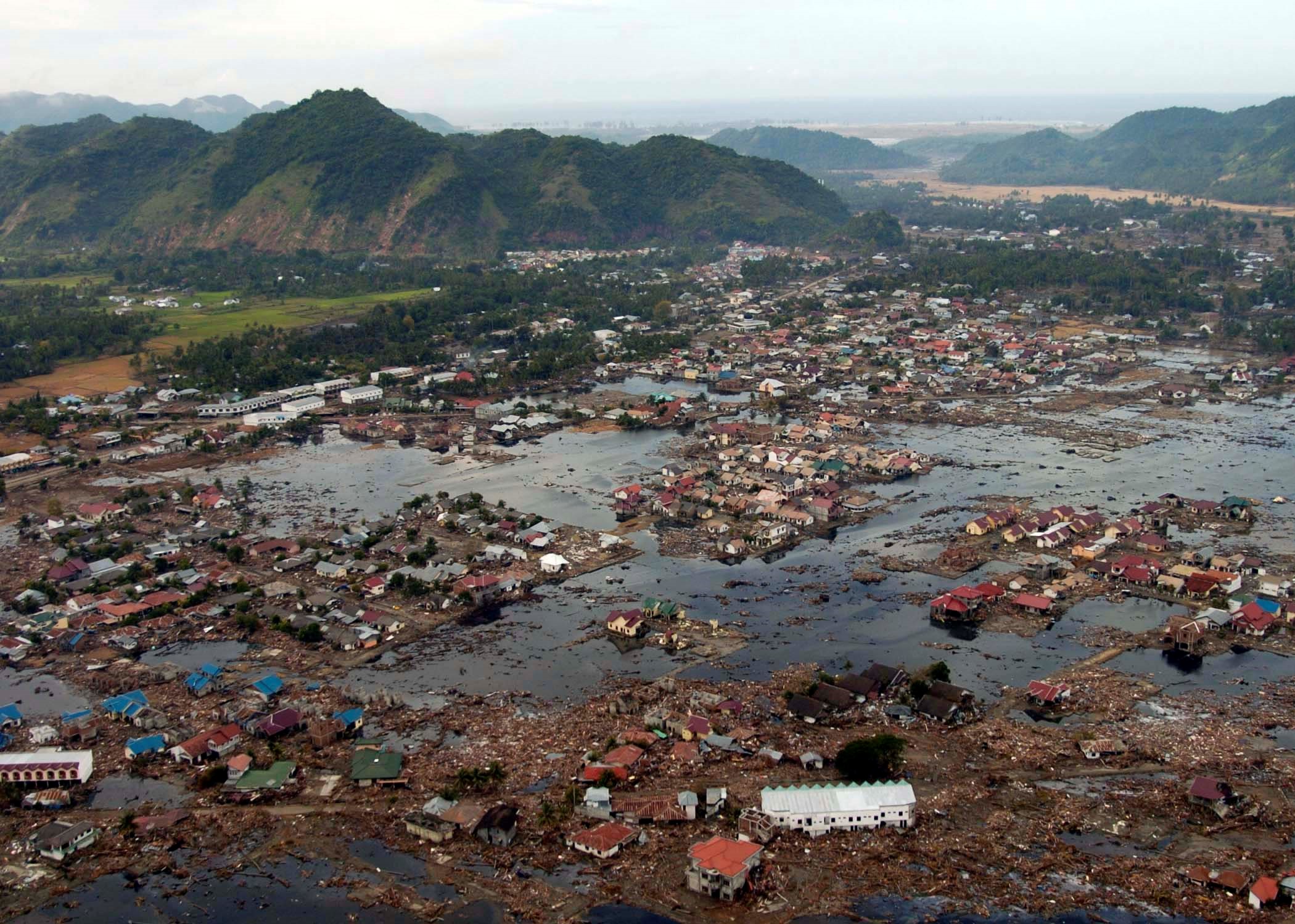
A tsunami, or seismic sea wave, is a great surge of the ocean’s surface caused by an underwater earthquake. A tsunami may be almost indiscernible in deep water of the open ocean, but it can become enormous when it reaches shallow coastal water and builds to a height capable of causing massive destruction. The greatest tsunami of recent times was triggered by an undersea, so-called “megathrust” earthquake on December 26, 2004. Its epicentre was located about 40 km off the coast of Aceh in northern Sumatra, an Indonesian island, and it registered a massive 9.2 on the Richter scale (making it the largest earthquake in 40 years). The tremor generated an immense tsunami (actually, a close series of individual waves) that gathered to a height up to 30 m when it impacted shallow-sloping coasts of countries fringing the Indian Ocean. Unfortunately, none of the countries that bore the brunt of the devastation were forewarned of the impending catastrophe, so no action was taken to move people from low-lying coastal areas to higher ground. This happened mostly because there was no tsunami-detection system in the Indian Ocean, although negligence was also involved because the extremely large earthquake should have alerted civil authorities to a potential catastrophe.
The colossal tsunami waves were moving at speeds of about 60 km/hr when they impacted the shore. They caused widespread devastation and more than 225,000 deaths by drowning and injuries caused by floating debris and collapsing buildings. The hardest-hit places were Sumatra (which suffered at least 168,000 dead and missing), Sri Lanka (35,000), the eastern coast and islands of India (18,000), and Thailand (8,000). At least 7,000 of the deaths were tourists from developed countries who were visiting coastal resorts during their holiday break. In addition to the mortality, tens of millions of people were displaced from their homes and livelihoods by the flooding. In many of the worst-hit places, the damage was made much more severe because of increased coastal vulnerability caused by the removal of previously abundant mangrove forest, mostly to develop tourist resorts and brackish ponds for shrimp aquaculture. Where mangroves remained intact, the coastal forest provided a sea-wall that helped to absorb much of the force of the tsunami, providing a measure of protection to areas further inland.
Responding to the overwhelming toll of death and destruction, citizens and governments of many non-affected countries delivered large donations of aid for rescue and subsequent recovery, including money (pledges totalled about US$5.4 billion), specialized rescue personnel, food and water, and materials for reconstruction. From the environmental perspective, important lessons to be learned from this devastating tsunami include the facts that natural disasters are unpredictable and inevitable, and that the ensuing destruction can be made much worse by inappropriate land-use practices and a lack of emergency planning and response capability.
A volcano is a vent in the surface from which molten lava flows onto the ground and liquid, solid, and gaseous materials are ejected into the atmosphere. The largest eruptions can literally explode a volcanic mountain, ejecting immense quantities of material into the environment and causing enormous damage and loss of life. For example, an eruption of Mount Vesuvius in the year 79 CE (Common Era) buried the Roman city of Pompeii, killing almost all of its inhabitants. A 1902 explosion of Mont Pelée on the Caribbean island of Martinique killed 30,000 people.
The greatest eruption of modern times was that of Tambora, a volcano in Indonesia that exploded in 1815 and blew more than 300 km3 of material into the atmosphere (including the top 1,300 m of the mountain). Some of the finer particulates of this massive eruption were blown into the upper atmosphere (the stratosphere), causing an increase in Earth’s reflectivity that resulted in global cooling. The year 1816 became known as the “year without a summer” in Europe and North America because of its unusually cool and wet weather, including frost and snowfall during the summer months.
Another famous Indonesian eruption was that of Krakatau in the Sunda Strait in 1883, which ejected 18-21 km3 of material as high as 50-80 km into the atmosphere. The 30-m tsunami associated with this eruption killed about 36,000 people in coastal villages.
Large volcanic eruptions can also disturb great expanses of forest and other ecosystems. For instance, the 1980 explosion of Mount St. Helen’s in the state of Washington blew down about 21,000 hectares of coniferous forest and otherwise damaged another 40,000 ha. Mudslides also devastated large areas, and a vast region was covered by particulate debris (known as tephra) that settled from the atmosphere.
Some volcanoes produce chronic lava flows and venting of gases. These volcanoes tend to form distinctive, cone-shaped mountains from their accumulated lava, which solidifies into finely crystalline, glassy rocks. An active example of this spectacular process is Mount Kilauea in Hawaii, which sometimes erupts continuously for years. The slowly flowing lava from these volcanoes can destroy buildings and vegetation but is not otherwise dangerous because people and animals can avoid the molten streams.
Glaciation
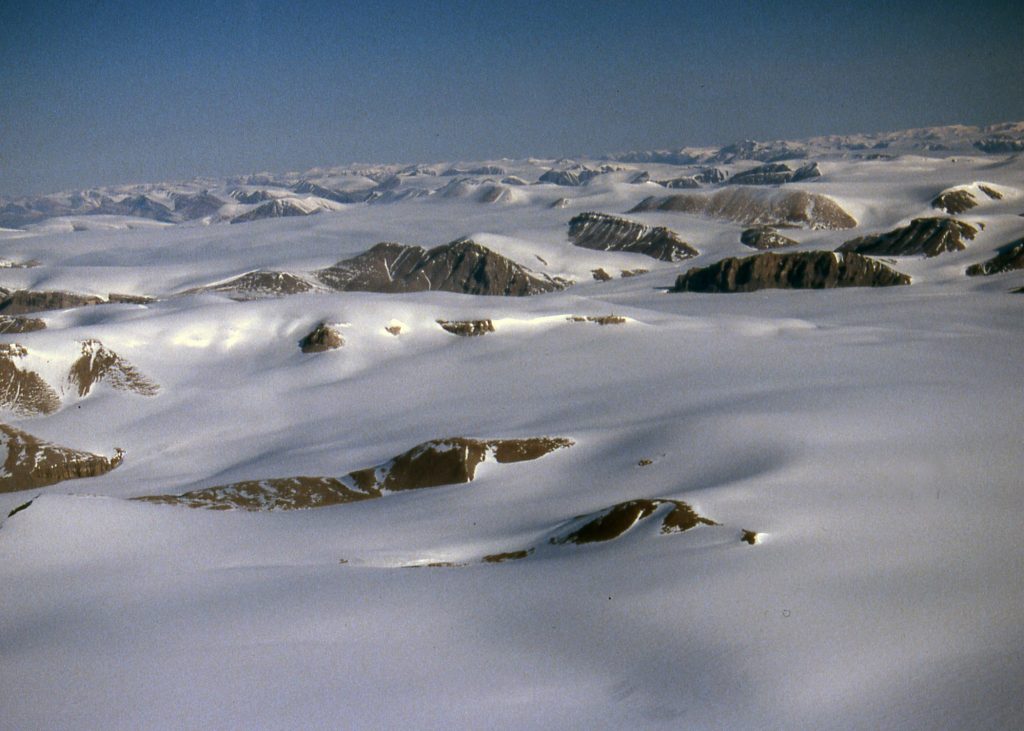
Glaciers, or persistent sheets of ice, are common features in high-latitude environments of the Arctic and Antarctic. They also occur at high altitude on mountains, even in tropical countries such as New Guinea and Peru. Glaciers are formed from a deep, persistent snowpack, which becomes compressed into ice as its weight accumulates. Most glaciers occur on land, but some also extend onto the ocean. At the present time, about 10% of the land surface of Earth is covered with glaciers, the largest of which are the continental ice sheets of Antarctica. The largest glaciers in the Northern Hemisphere are in Greenland, but parts of Baffin and Ellesmere Islands in the Canadian Arctic are also covered with glacial ice, as are some mountainous areas in western Canada.
Glaciation refers to an extensive advance of ice sheets, caused by a period of extended global cooling sometimes referred to as an ice age. There have been a number of glacial periods during geological history, although details are known only about the most recent glaciation because it obliterated most traces of earlier events. The most recent glacial period, known as the Wisconsin, began about 85,000 years ago and ended about 11,000 years ago.
At the height of the Wisconsin glaciation, ice covered about 30% of Earth’s land surface, including almost all of what is now Canada, as well as extensive areas of the continental shelf that are now beneath the ocean. The latter occurred because sea level was about 120 m lower during that glaciation as a result of so much water being tied up in ice on land. The greatest ice mass in Canada was the Laurentide Ice Sheet, which reached a thickness of about 4 km. The Cordilleran Ice Sheet of the western mountains contained ice up to 2 km thick.
The present Holocene (recent; Table 3.1) epoch is relatively warm and ice-free and is referred to as an interglacial stage. Climate has not, however, been uniformly warm during the present interglacial. For example, the period of about 1450 to 1850 is known as the Little Ice Age because of its relatively cool climate. During that period there was a moderate expansion of glaciers and snowfields in many parts of the world, including the Arctic regions and western mountains of Canada.
Glaciers are extremely erosive forces that crush, scour, and excavate the underlying terrain with their massive weight and ponderous movements. Glaciers also transport huge quantities of excavated debris around the landscape. These solid materials are eventually deposited when the glaciers melt, tumbling from the ablating (melting) ice mass or being carried away by meltwater running in streams and rivers. Extensive deposits of glacial debris are common over almost all of Canada, often occurring as distinctive landforms, such as the following:
- moraines, which are a series of long, mounded hills, usually lying perpendicular to the flow of the regional glacier, and containing mixed rocky debris known as till
- drumlins, or teardrop-shaped hills that are elongated in the direction of movement of the glacier and are composed of a mixture of rocky materials
- eskers, which are long, serpentine mounds of crudely sorted debris that was deposited by a river flowing beneath a glacier
- erratics, or rounded boulders of various sizes that are incongruously scattered over the landscape
- long U-shaped valleys in mountainous terrain, which were carved from pre-existing river valleys by the erosive forces of a glacier
- fiords, which are long, narrow, steep-sided inlets of the ocean that were carved by outlet glaciers descending from a much larger ice sheet at higher altitude
- outwash plains, which contain a mixture of materials, ranging in size from rocks to sand or clay, that were deposited over a relatively wide area by streams and rivers fed by glacial meltwaters
- the former basins of large lakes of glacial meltwater, which today are characterized by flat, fine-grained, often fertile plains (Southern Manitoba has extensive former lakebeds of postglacial Lake Agassiz, while flat areas in southern Ontario and Quebec were once part of the postglacial basins of what are now the Great Lakes and St. Lawrence River.)
The tremendous ice sheets that once obliterated almost all of Canada were largely gone by 8,000 to 10,000 years ago, although glacial remnants still occur on islands in the Arctic and on mountains of western Canada. The Canadian landscape has been profoundly shaped by the impressive geological signatures of the advance and retreat of the immense continental glaciers of times past. Since then, the terrain and landforms have been greatly modified by other geological forces, such as erosion and weathering, and by the redevelopment of ecosystems after the retreat of the immense ice sheets. However, compared with the effects of the Wisconsin and previous glaciers, those forces have had a relatively small influence on the enduring character of the landscapes and coastal seascapes of Canada.
Weathering and Erosion
Meteorite impacts, earthquakes, volcanic explosions, and glaciation are all tremendous geological forces – they are capable of obliterating both natural and anthropogenic ecosystems. However, less forceful geological dynamics are also important, although they exert their influences more pervasively, by operating relatively slowly over longer time scales rather than as extremely destructive events.
Weathering refers to physical and chemical processes by which rocks and minerals are broken down by environmental agents. Non-biological (abiotic) forces of weathering include rain, wind, and temperature changes (especially freeze-thaw cycles). Biological forces include the rock-cracking powers that are exerted by plant roots. Weathering proceeds by the fracturing of rocks and by the solubilization (chemical decomposition) of minerals by acidic rainwater and by corrosive excretions of plant roots and microorganisms.
Erosion refers to the removal of rocks and soil through the actions of gravity, flowing water, ice, and wind. Erosion is a pervasive geological process, occurring at various rates in all environments. Usually it is gradual, occurring as particles are slowly removed by flowing water or blowing wind, or when dissolved minerals are carried away by underground flows of water. However, erosion also occurs as mass events, such as a landslide in steep terrain. Over extremely long periods of time, weathering and erosion tend to influence the landscape towards a relatively flat and homogeneous condition known as a peneplain.
Even geological features as immense as mountains are slowly eroded away, with their enormous mass gradually descending to be deposited in lower regions. For instance, the Precambrian Shield that is so extensive in regions of Canada is composed of the granitic basement rocks of ancient mountains that were slowly eroded away by the actions of water, wind, and glaciers. The somewhat less ancient hills of the Appalachians of eastern North America, which extend into New Brunswick, Nova Scotia, and Newfoundland, are also the eroded relics of a once-great mountain range. The youngest mountain range in North America, the Rocky Mountains, extends from the western United States north into Alberta, British Columbia, the Yukon, and the western Northwest Territories. The Rockies still have many towering, sharp peaks because they have not yet been much reduced by the inexorable, mass-wasting forces of erosion.
The rates of natural weathering and erosion is influenced by many factors, including the hardness of rocks, degree of consolidation of soil and sediment, amount of vegetation cover, rate of water flow, slope of the land, speed and direction of winds, and frequency of storm events and other disturbances. Some of these factors can be greatly influenced by human actions. For example, when the local vegetation is disturbed, its moderating influence on erosion is reduced or eliminated. In fact, human activities associated with agriculture, forestry, and road-building have greatly increased the rates of erosion in almost all regions of the world. In many cases, the increased losses of soil have had serious consequences for the productivity of agricultural land and for natural biodiversity (see Chapters 14, 20, 23, and 24).
Rocks, sand, clays, and other debris eroded from mountains and other uplands must, of course, go somewhere. These materials are carried to lower altitude, and eventually much of the mass is deposited in the oceans, where they settle to the bottom in a process known as sedimentation. Over extremely long periods of time (tens or more millions of years), the mass of sedimented material builds up to the extent that intense pressure is exerted on lower levels of the sediment, which causes it to become more densely packed and fuse into sedimentary rock in a process called lithification. Examples of sedimentary rocks are mudstone, sandstone, shale, limestone, and mixtures of these known as conglomerates (the latter may also contain eroded non-sedimentary rocks, such as granite and basalt).
Eventually, under the influence of tectonic forces, enormously slow and powerful collisions of crustal plates can cause areas of deep-oceanic sedimentary rocks to uplift, sometimes raising them to great altitude and contributing to the formation of new mountain ranges underwater or on the continents. As such, geological uplift is the means by which marine rocks and fossils find their way to the tops of the highest mountains. Uplift and mountain building are important stages in the geological recycling of some of the continental mass that was wasted downslope during millions of years of erosion.
The Hydrosphere
The hydrosphere is the portion of Earth that contains water (H2O), including in the oceans, atmosphere, land surface, and underground. The hydrologic cycle (or water cycle) refers to the rates of movement (fluxes) of water among these various reservoirs (compartments). The hydrologic cycle functions at all scales, ranging from local to global. The major elements of the global hydrologic cycle are illustrated in Figure 3.2.
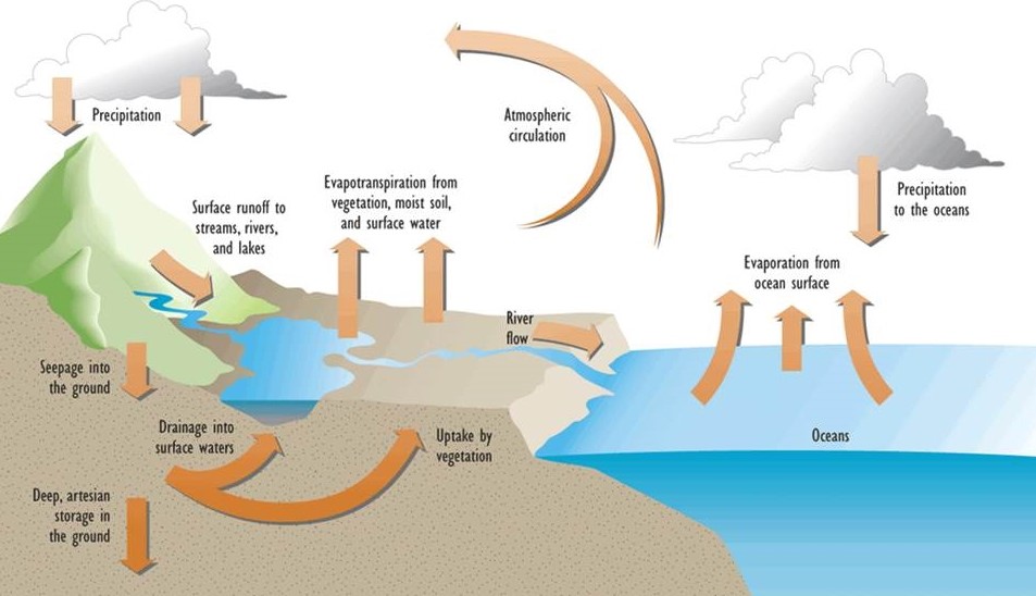
Each compartment of the hydrologic cycle has both input and output fluxes, and the sum of all of these elements comprises the cycle. If the rate of input to a compartment equals the rate of output, then there is a flow-through equilibrium and the amount of water present does not change. Of course, if input exceeds output, the compartment increases in size over time, and it decreases if input is less than output.
On the global scale, the major compartments of the hydrologic cycle are in a long-term equilibrium condition. However, this is not generally true on a local scale, especially over shorter intervals of time. For example, a particular area may temporarily flood or dry out. In addition, local hydrological conditions can change over the long term. Glaciation, for example, stores immense quantities of solid water on land, and excessive use of groundwater can deplete an artesian reservoir (aquifer).
Although the hydrologic cycle is an exceedingly complex phenomenon, it can be examined in the context of four major compartments (Table 3.2):
- The oceans are the largest hydrological compartment, accounting for about 97.4% of all water on the planet.
- Surface waters occur on the landmasses and account for 2.3% of global water. Almost all that amount is tied up in glaciers, mostly in Antarctica and Greenland, with lakes, ponds, rivers, streams, and other surface bodies of liquid water amounting to only 0.002%.
- Groundwater accounts for 0.32% of global water. Groundwater can occur in relatively shallow soil horizons, where it is accessible for uptake by plants, or it can drain laterally into surface waters such as lakes and streams. Deeper groundwater is inaccessible for these purposes and it forms artesian reservoirs in spaces within porous or fractured bedrock. Such aquifers receive water infiltrating by deep drainage from above or by long-distance underground transport from nearby upland areas.
- Atmospheric water accounts for only about 0.001% of the global total. It can occur as a gas, vapor (tiny, suspended droplets), or solid (ice crystals), all of which are highly variable over space and time. A cloud is a dense aggregation of liquid or solid water in the atmosphere, while gaseous water is invisible. Note that the maximum amount of water a volume of atmosphere can hold is highly dependent on temperature, with warmer air having a much greater water-storage capacity than cold air. The term humidity refers to the actual concentration of water in the atmosphere (measured in g/m3), while relative humidity expresses actual humidity as a percentage of the saturation value for a particular temperature.
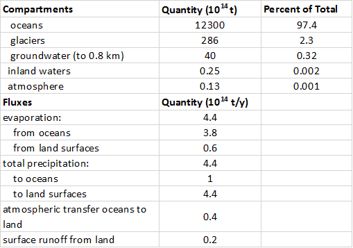
Evaporation is a change of state of water from a liquid to a gas, or from a solid directly to a gas (evaporation directly from ice or snow is more properly referred to as sublimation). Globally, about 86% of evaporation is from the oceans, and the rest is from terrestrial surfaces. On terrestrial landscapes, water can evaporate from bodies of surface water, from moist soil and rocks, and from vegetation. Transpiration refers specifically to the evaporation of water from plants, while evapotranspiration refers to all sources of evaporation from a landscape.
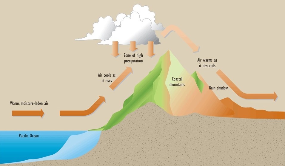
Precipitation is the deposition of water from the atmosphere, occurring as liquid rain or as solid snow or hail. In addition, vapor-phase atmospheric water can condense or freeze onto surfaces as dew or frost, respectively. As previously noted, most global evaporation is from the oceans, much of which precipitates back to them. However, some is transported by moving air masses over the continents, resulting in a net import of evaporated water from the oceans to the land surfaces. Precipitation volumes can be especially large in mountainous areas facing an ocean, a phenomenon known as orographic precipitation (In Detail 3.1).
Surface flows involve water that is transported in streams and rivers. In contrast, lakes and ponds are relatively static storage reservoirs. Surface flows move in response to gravitational descents associated with altitude – in other words, water flows downhill. Ultimately, most surface flows carry water to the oceans, thereby helping to balance the net import of moisture evaporated from the oceans.
The spatial pattern of precipitation in coastal British Columbia illustrates the phenomenon of orographic precipitation. It occurs as moisture-laden air masses, blown by the prevailing westerly winds from the Pacific Ocean, encounter the mountains of the Coast Range. As the air masses rise, they cool (by 0.5 to 0.8°C for every 100 m increase in elevation), which greatly reduces their ability to hold water. This causes much of the moisture to condense into clouds and to then precipitate from the atmosphere as snow and rain.
As the air mass passes to the other side of the mountains and starts to descend, it warms again, which increases its moisture-holding capacity. Therefore, precipitation is much sparser on the rain-shadow side of the mountains.
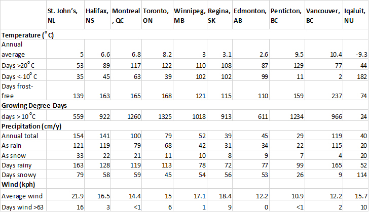
Consequently, coastal Vancouver has much more rainfall (about 110 cm/y) than Penticton in the inland Okanagan Valley (28 cm/y). However, local orographgic effects are also considerable in the Greater Vancouver area, where rainfall is only about 50 cm/y in the southern suburbs of Delta, but as much as 250 cm/y in places nearer the mountains, such as North Vancouver.
Groundwater drainage involves the infiltration of water into the ground. Shallow groundwater can move laterally, eventually draining into surface waters. It can also be taken up by plant roots to later be transpired into the atmosphere through foliage. However, deeper groundwater is not available for plant uptake or to recharge surface waters. It accumulates in underground artesian reservoirs, which can be very large. The biggest such aquifer in North America is the Ogallala, which underlies about 450,000 km² of the western U.S.
The hydrologic cycle is extremely important. Water is needed by natural ecosystems for the metabolic needs of organisms, for cooling, and as a ubiquitous solvent that allows water-soluble nutrients to be absorbed by organisms. Water is also required by people for use in agriculture, industry, and recreation. Unfortunately, in many regions water and its biological resources (such as fish) have been used excessively, and water quality has been degraded through pollution. Damages caused to water and its resources, and ways of mitigating those effects, are common themes in many chapters in this book.
The Atmosphere
The atmosphere is an envelope of gases that surrounds the Earth and is held in place by the attractive forces of gravity. The density of the atmospheric mass is much greater close to the surface and decreases rapidly with increasing altitude. The atmosphere consists of four layers, the boundaries of which are inexact because they may vary over time and space:
- The troposphere (or lower atmosphere) contains 85-90% of the atmospheric mass and extends from the surface to an altitude of 8-20 km. It is thinner at high latitudes, and thicker at equatorial latitudes, but also varies seasonally, at any place being thicker during the summer than in the winter. It is typical for air temperature to decrease with increasing altitude within the troposphere, and convective air currents (winds) are common. Consequently, the troposphere is sometimes referred to as the “weather layer.”
- The stratosphere extends from the troposphere to as high as about 50 km, depending on the season and latitude. Air temperature varies little with altitude within the stratosphere, and there are few convective air currents.
- The mesosphere extends beyond the stratosphere to about 75 km.
- The thermosphere extends to 450 km or more.
Beyond the atmosphere is outer space, an immeasurably vast region where the Earth exerts no detectable chemical or thermal influences.
About 78% of the mass of the atmosphere is composed of nitrogen gas (N2), while 21% is oxygen (O2), 0.9% argon (Ar), and 0.04% carbon dioxide (CO2). The rest is various trace gases, including potentially toxic ones such as ozone (O3) and sulphur dioxide (SO2) (see Chapter 16). The atmosphere also contains highly variable concentrations of water vapor, which can range from only 0.01% in frigid winter air in the Arctic to 5% in warm, humid, tropical air. On average, the total weight of the atmospheric mass exerts a pressure at sea level of around 1.0 × 10⁵ pascals (Pa; or one atmosphere), which is equivalent to 1.0 kg per cm2.
The atmosphere is a highly dynamic medium, being variable over space and time. This is particularly true of the troposphere, within which gradients of temperature and energy are most pronounced. To even out the energy gradients, there is a streaming of atmospheric mass from regions of relatively high pressure to those with lower pressure. These more-or-less lateral atmospheric movements are known as wind. The vigour and speed of winds can range from barely perceptible to several hundred kilometres per hour in extremely turbulent, rotating air masses such as a tornado or hurricane. In general, winds are caused when air heated by the sun becomes less dense and rises in altitude, to be replaced at the surface by an inflow of cooler, denser air from elsewhere. Simply interpreted, this movement of atmospheric mass represents an enormous gaseous convective cell. These atmospheric movements occur on both local and global scales and are extremely variable over space and time. At the global level, however, a broad general pattern of circulation is discernible.
As was noted above, wind directions are influenced by the relative locations of high and low atmospheric pressures. Wind directions are also influenced by the Coriolis effect, which is caused by the west-to-east rotation of Earth. For example, in the mid-latitudes of the Northern Hemisphere, the distribution of pressure in the lower atmosphere provides a northward force on wind direction. The Coriolis force, which deflects motions to the right in that hemisphere, balances the pressure-gradient force so that the winds tend to blow from west to east. In comparison, in the mid-latitudes of the Southern Hemisphere, the pressure gradient force is directed toward the south, while the Coriolis force deflects motions to the left. On balance, this again results in winds tending to blow from west to east. Local patterns of wind flow are also influenced by surface topography—mountains are barriers that deflect winds upward or around, while valleys can channel wind flows.
Prevailing winds blow relatively continuously in a dominant direction. There are three major classes of prevailing winds:
- trade winds are tropical airflows that blow from the northeast (to the southwest) in the Northern Hemisphere, and from the southeast in the Southern Hemisphere
- westerlies are mid-latitude winds that blow from the southwest in the Northern Hemisphere, and from the northwest in the Southern Hemisphere
- polar easterlies blow from the northeast at high northern latitudes, and from the southeast near Antarctica.
Climate and Weather
Climate refers to the prevailing atmospheric conditions of temperature, precipitation, humidity, wind speed and direction (together, these are wind velocity), insolation (incoming solar radiation), visibility, fog, and cloud cover in a place or region. Climatic data are usually calculated as statistics (such as averages or ranges of values), using data obtained from at least several decades of monitoring (the preferred period for the calculation of “normal” climatic parameters is at least 30 years).
In contrast, weather refers to day-to-day or instantaneous meteorological conditions (the latter is referred to as “real-time” weather). Because weather is related to short-term conditions, it is much more variable over time and space than climate. Most aspects of climate are functions of solar insolation and of how this incoming energy is absorbed, reflected, and re-radiated by the atmosphere, oceans, and terrestrial surfaces. The complex subject of physical energy budgets is described in Chapter 4. For the present purpose, it is worthwhile to examine several ecologically important aspects:
- Give Thanks to the Sun. If it were not for the warming influence of solar radiation, the temperature of the surface and atmosphere would approach the coldest that is physically possible – this is absolute zero, or -273°C (or 0o on the Kelvin scale). Although Earth has a limited ability to generate its own heat by the decay of radioactive elements in its core, this is insufficient to provide much warming at the surface. Therefore, solar energy is critical to maintaining the surface temperature within a range that organisms can tolerate.
- Atmospheric Reflection and Absorption. Conditions in the atmosphere have a great influence on climatic factors. For instance, cloud cover and tiny particulates are highly reflective of many visible wavelengths of solar radiation and so have a marked cooling effect on the lower atmosphere and the surface. In addition, the atmosphere contains trace concentrations of certain gases that absorb some of the infrared radiation that the planet emits to cool itself of the heat obtained by absorbing solar radiation. The most important of these so-called “greenhouse gases” are water vapor, carbon dioxide, and methane. This influence is called the greenhouse effect, and it maintains the surface temperature of Earth at an average of about 15°C, or 33°C warmer than the -18°C it would be without this moderating effect (see Chapters 4 and 17).
- Night and Day. At any place on the surface, the input of solar radiation is high during the day and low at night. (At night, the only radiation inputs are from distant stars and from solar radiation reflected by atmospheric particulates and the moon—these sparse inputs are known as “skylight.”) The daily, 24-hour (diurnal) variations in energy input result in large changes in weather. However, this effect varies greatly between tropical and polar latitudes. Tropical regions have approximately equal day and night lengths of about 12 hours each, which do not vary much during the year. In contrast, polar latitudes are much more seasonal, with almost continuous light during much of the summer, and constant night during part of the winter. Temperate latitudes are intermediate, with longer day lengths during the summer and shorter ones during winter.
- Effects of Latitude. Places at tropical latitudes tend to face incoming solar radiation on a relatively perpendicular angle (closer to 90° at noon). Polar latitudes have a more oblique angle of solar incidence, and temperate latitudes are intermediate in this regard. The more perpendicular the angle of incidence of solar radiation is, the smaller the surface area over which the incoming energy is distributed and the more intense the resulting heating. The angle of solar incidence has a strong influence on the amounts of unit-area solar radiation that are received at various latitudes, and is a major reason (along with seasonality) why the tropics are warmer than polar regions.
- Seasons. Earth’s axis tilts at a 23.5° angle relative to the incidence of solar radiation. Consequently, during the planet’s annual revolution around the Sun, there are seasonal differences in energy received between the Northern and Southern Hemispheres. In the Northern Hemisphere, the angle of incidence is closer to perpendicular from March 21 to September 22, giving relatively warmer conditions, while the angle is more oblique from September 22 to March 21, resulting in cooler conditions. These seasons are reversed in the Southern Hemisphere. Because Earth’s orbit is elliptical, climatic seasons are also influenced by the varying distance from the Sun. However, this effect is relatively small compared with that of the inclination of the axis.
- Aspect. On a local scale, the direction that a slope faces (known as its aspect) has a substantial influence on the amount of solar radiation received. In the Northern Hemisphere, south-facing, and to a lesser degree west-facing slopes are relatively warm, while north- and east-facing slopes are cooler. In the Southern Hemisphere, north-facing slopes are warmer.
- Slope. The degree of slope, or the angle of inclination of the land, also affects the amount of energy received. The closer the slope approximates a perpendicular angle to incoming solar radiation, the greater is the energy input per unit of surface area. In the Northern Hemisphere, this effect is greatest on south-facing slopes.
- Soil and Vegetation Cover. Darker surfaces absorb much more solar radiation than do lighter surfaces. This is the reason why a black asphalt surface gets much hotter during the day than one made of light-coloured cement. Plant canopies also vary in their absorption and reflection characteristics, depending on the colour of the foliage and the angle at which it is oriented to incoming solar radiation. Major changes in the character of vegetation, as occur when forest is converted into agricultural or urban land-use, can affect local, and sometimes regional, weather and climate.
- Snow and Ice Cover. Because snow and ice are highly reflective of solar radiation, surfaces covered by those materials absorb relatively little insolation. The melting of snow cover in the springtime exposes a much more absorptive ground surface, and warming then accelerates.
- Evaporation of Water. Moist surfaces are cooled by the evaporation of water, a process that absorbs thermal energy. Therefore, the transpiration of water from plant foliage has a cooling effect, similar to the evaporation of sweat from the body surface of a human.
The above factors influence the input, reflection, absorption, and dissipation of solar radiation, resulting in large variations of air, water, and surface temperatures over the surface of Earth. The energy gradients that develop result in global processes that attempt to distribute the energy more evenly, by movements of air masses in the atmosphere (winds) and currents of water in the oceans. In addition, prevailing wind directions can interact with oceanic currents to generate circular water flows known as gyres. Subtropical gyres rotate clockwise in the Northern Hemisphere and counter-clockwise in the Southern Hemisphere, while subpolar gyres rotate in the opposite directions.
Climate has an important influence on the character of ecological development in any region or place. Climatic conditions can vary on a large scale, called macroclimate, which affects the nature of ecosystems over a large area. Climatic conditions can also vary on much smaller scales, called microclimate, which may be affected by local topography, proximity to the ocean or a large lake, or understorey conditions beneath a dense canopy of tree foliage. Four climatic factors particularly affect the development of ecosystems (see Chapter 8). Of these, variations of precipitation and temperature generally have the greatest influence. The amounts of precipitation are greatly affected by the flow of prevailing winds, the humidity of air masses, and the influence of topography (see In Detail 3.1). A dry climate may only support desert vegetation, whereas wetter conditions may allow old-growth forest and wetlands to develop.
Temperature is relatively warm in tropical latitudes and at lower altitude in mountainous terrain, while it is cooler at high latitude and high altitude. In general, places with cold temperatures develop tundra vegetation, whereas warmer temperatures may support forest. Temperate and polar latitudes have large seasonal fluctuations in temperature. Tropical forest develops in moist regions where temperature remains uniformly warm, while temperate and boreal forests are dominated by tree species that can tolerate cold temperatures during the winter. Wind can also have a substantial ecological influence, although this is typically less important than that of precipitation and temperature. Very windy locations may not be able to support forest, even though precipitation and temperature are otherwise favourable. This occurs in many coastal habitats in Canada, where windy conditions result in shrub-dominated ecosystems rather than the forest that occurs farther inland.
Extreme events of weather, such as drought, flooding, a hurricane, or a tornado, can also be important. Severe disturbances have a large influence on ecological development, especially where they occur frequently. For example, frequent drought or severe windstorms may restrict the development of forest in some regions, even though the average climatic conditions may be favourable.
Major elements of the climates of Canada are described in Canadian Focus 3.1. Their relationship with ecological development is examined in Chapter 8.
Canadian Focus 3.1. Climates of Canada
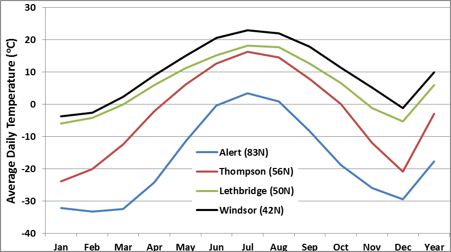
Canada is a huge country, the second largest in the world after Russia. The wide range of latitude means that local and regional climates vary from cold polar in the High Arctic to warm temperate in southern Ontario and southern British Columbia. Canada also has extremely varied topography, with extensive low regions and many areas at high elevation, particularly in the mountains of Labrador, the eastern Arctic Islands, and the Rocky Mountains. Therefore, the regions of Canada are characterized by huge differences in climate.
The figure shows seasonal patterns of change, using temperature as an indicator. Note that the high-Arctic station at Alert (82o N) on far-northern Ellesmere Island is much colder and has a brief growing season compared with the southerly stations. Thompson (55o N) is in the boreal zone of northern Manitoba and it also has a relatively cold climate with a short growing season. Lethbridge, in the prairie region of southern Alberta, has a temperate prairie climate with a relatively warm and extended growing season. Windsor (42o N) is the most southern location shown, and it has the warmest climate and longest growing season.
Conclusions
Knowledge of the physical world is a central aspect of environmental science – it provides essential context for understanding the causes and consequences of almost all changes that are caused by human activities. The physical and structural attributes of Earth influence the geological and geographical forces affecting its surface (both water and land) and atmosphere. In addition, the amount and spectral quality of incoming sunlight have a profound influence on the energy budget and climates of the planet. Increasingly, anthropogenic influences are having a large, cumulative effect on these natural effects and are transforming the surface attributes of Earth by affecting erosion, surface cover, environmental chemistry, and even global climate.
Questions for Review
- What are the various layers of Earth’s solid sphere and atmosphere? Briefly describe the characteristics of these layers.
- What causes tectonic forces, and what are their consequences on crustal dynamics?
- What is glaciation? Describe the major surface features that it leaves behind.
- What are key factors affecting regional climate and microclimate?
Questions for Discussion
- Explain how geological forces have influenced landscape features in the region where you live.
- Where does your drinking water come from? Trace its origins and disposal in terms of the hydrologic cycle.
- Explain the differences between climate and weather. Discuss the influences of climate and weather on your daily and annual life.
- Natural disasters, such as extreme weather caused by a windstorm or massive rain event, are rare but inevitable occurrences. What is the recent history of natural disasters in the place where you live? Do you think that land-use and other human influences may have increased the possibility of worse damage being caused by these unpredictable events?
Exploring Issues
- You are part of a research team that is investigating the potential environmental effects of climate change in a region of hilly topography. Your responsibility is to characterize the climatic conditions in the study area, giving sufficient detail so the team can understand the overall conditions as well as the local ones, such as in valleys, on slopes, and on hilltops. What kinds of factors would you have to consider when designing the climate-monitoring program? Consider the following aspects: (a) the number of monitoring sites, (b) where monitoring sites should be located, (c) what variables to measure (such as wind, temperature, precipitation, sunlight), and (d) how long you must monitor conditions before determining the normal climate (as opposed to the weather).
References Cited and Further Reading
- Alvarez, W., E.G. Kauffman, F. Surlyk, L.W. Alvarez, F. Asaro, and H.V. Michel. 1984. Impact theory of mass extinctions and the invertebrate fossil record. Science, 223: 1135-41.
- Botkin, D.B. and E.A. Keller. 2014. Environmental Science: Earth as a Living Planet. 9th ed. J. Wiley & Sons, New York, NY.
- Bryant, E.A. 1997. Climate Process and Change. Cambridge University Press, Cambridge, UK.
- Cowen, R. 2013. History of Life. 4th ed. Blackwell Sci. Pub., London, UK.
- Environment Canada. 2015. Canadian Climate Normals. Atmospheric Environment Service, Ottawa, ON. http://climate.weather.gc.ca/climate_normals/index_e.html#1981
- Flint, R.F. and B.J. Skinner. 1987. Physical Geology. J. Wiley & Sons, New York.
- Jablonski, D. 1991. Extinctions: A Paleontological Perspective. Science, 253: 754-7.
- Keller, E.A. 2010. Environmental Geology. 9th ed. Prentice Hall, Upper Saddle River, NJ.
- Lutgens, F.K., E.J. Tarbuck, and D.G. Tasa. 2011. Essentials of Geology. 11th ed. Prentice Hall, Upper Saddle River, NJ.
- Margulis, L. and L. Olendzenski (eds.). 1992. Environmental Evolution. MIT Press, Cambridge, MA.
- Montgomery, K. 2002. Environmental Geology. McGraw-Hill, Columbus, OH.
- Odum, E.P. 1993. Basic Ecology. Saunders College Publishing, New York, NY. Priest, J. 2012. Energy: Principles, Problems, Alternatives. 8th ed. Kendall Hunt
- Pielou, E.C. 1991. After the Ice Age: The Return of Life to Glaciated North America. University of Chicago Press, Chicago, IL.
- Raup, D.M. 1986. The Nemesis Affair. Norton, New York, NY
- Schneider, S.H. 1989. The Changing Climate. Scientific American, 261 (3): 70-9.
- Skinner, B.J., S.C. Porter, and J. Park. 2004. Dynamic Earth: An Introduction to Physical Geology, 5th ed. John Wiley & Sons, New York, NY.
- Smil, V. 2007. Energy in Nature and Society. General Energetics of Complex Systems. MIT Press, Boston, MA.
- Van Andel, T.H. 1985. New Views on an Old Planet: Continental Drift and the History of the Earth. Cambridge University Press, Cambridge, UK.